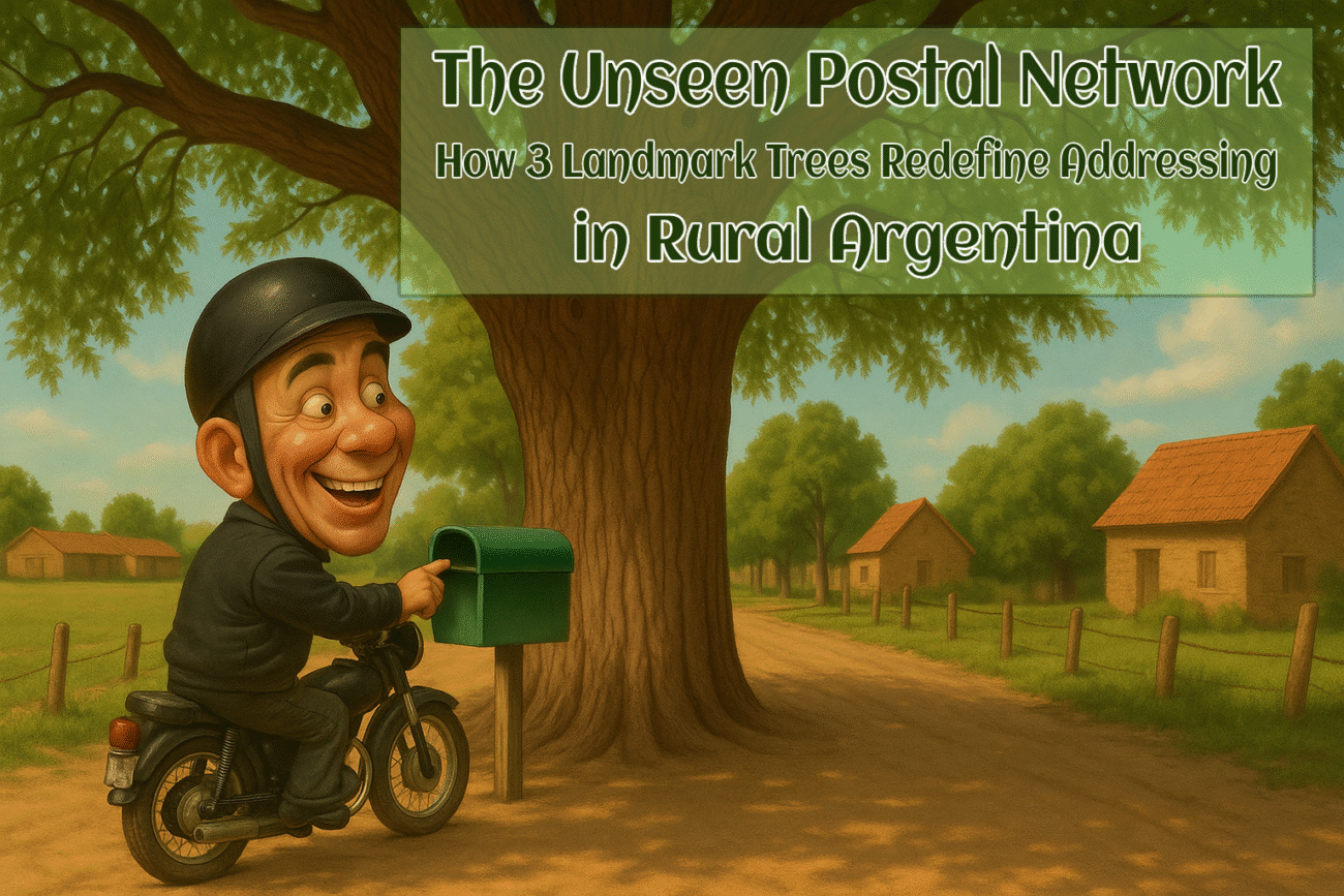

In the vast, sun-drenched expanses of rural Argentina, where paved roads dissolve into dirt tracks and houses are scattered like seeds in the wind, a conventional address is a foreign concept. There are no street numbers, no neat rows of mailboxes, and often, no officially named roads. Yet, letters find their way, packages arrive, and a sense of order prevails, all thanks to an elegant, organic system of communication. Here, the postal network is not written in code but grown from the earth itself.
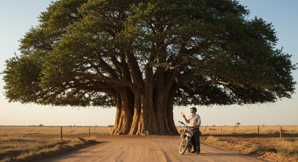
It relies on silent, steadfast sentinels that have stood for generations: the Landmark Trees. This unique method of wayfinding is a profound testament to human ingenuity, an informal postal system born from necessity, and a living example of natural navigation that shapes the very fabric of community identity. This is not merely a quaint anecdote but a functioning, resilient system of rural Argentina addressing. Imagine a postal worker, a cartero, navigating not by a GPS that has long lost its signal, but by a description passed down through conversation: “Go past the old estancia gate, and where the road forks, look for the big Ombú.
You can’t miss it. The house is a few hundred meters beyond that, on the right.” In this world, a gnarled Quebracho or a sprawling Tipa is more reliable than a satellite.[1] This article delves into the deep-rooted tradition of using Landmark Trees as locational anchors in Argentina, exploring the origins of this system, its practical mechanics, its deep cultural significance, and its surprising endurance in an age of relentless digitization.
The Genesis of a System: Why Trees Became Addresses
The fundamental challenge of rural Argentina addressing lies in its geography. The country’s landscape is famously diverse, from the arid north to the fertile Pampas, but a common feature of its rural areas is immense space and sparse population. Traditional estancias, or ranches, can cover thousands of hectares, with homesteads separated by vast distances. In these remote regions, the infrastructure of modern addressing numbered streets, postal codes, and detailed maps was never implemented, largely because it was impractical.
Poverty and a historical urban policy bias have also meant that rural areas often lack the investment in formal infrastructure seen in cities. As a result, a formal address becomes meaningless when there is no street to name or number to assign. [2] This lack of formal structure creates a logistical vacuum. For the national postal service, Correo Argentino, and private operators, delivering mail to these areas presents unique difficulties. While they face typical challenges like weather disruptions, the primary hurdle is often inaccurate or non-existent address information.
In a 2010 interview, an executive from OCA, a major private postal operator, noted that while reaching rural areas is feasible, the main problems are incorrect zip codes or a lack of updated address details. This is where the local, community-driven solution proves its worth. Long before digital maps, people relied on the oldest form of cartography: the landscape itself.[3]
This is the essence of natural navigation, an ancient human skill of finding one’s way using environmental clues like the sun, stars, and terrain. In the largely flat or rolling landscapes of the Pampas, a tall, distinctive tree is the most prominent feature for miles. Visible from afar, these trees became natural waypoints. Species like the Ombú (Phytolacca dioica), often called the “lighthouse of the Pampas,” with its massive, umbrella-like canopy, or the resilient Quebracho, a symbol of strength, are ideal for this purpose.
Their longevity means they can serve as markers for generations, becoming fixtures in the collective memory of a place. The use of these Landmark Trees was not a top-down decree but an organic solution that evolved over time, a perfect example of an informal postal system created and maintained by the very people it serves. It is a system built on shared knowledge rather than standardized data.
A Day in the Life of the Cartero: How the System Works in Practice
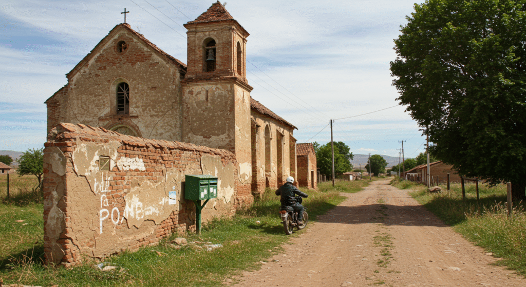
To truly understand this system, one must follow the journey of a rural mail carrier, the cartero. Their day begins not by programming a route into a GPS, but by mentally mapping a series of stories and descriptions. The instructions they carry are a form of oral tradition: “For the Garcia family, you take the dirt path after the river, and you’ll see a trio of eucalyptus trees. Their gate is just past the trees, painted blue.” This informal postal system is predicated on a deep, shared understanding of the local landscape, a knowledge that is passed between residents and the postal workers who serve them.
It is a system built on human connection. The process highlights a stark contrast with the impersonal nature of urban mail delivery. The cartero is not just a delivery agent but an integral part of the community’s communication network. They are a trusted figure who knows the people as well as the places. This reliance on human memory and direct communication is surprisingly effective. While a GPS might struggle with unmapped roads or poor satellite reception, a seasoned cartero can navigate by instinct and experience.
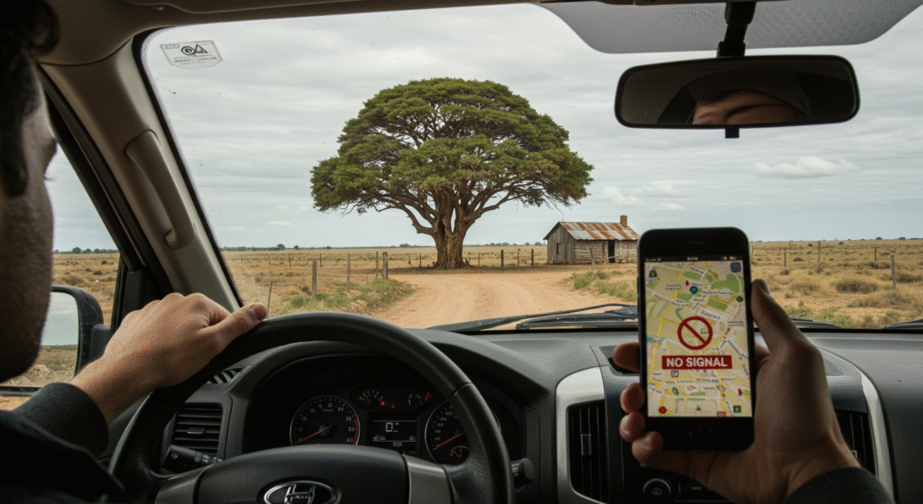
In many remote areas, this form of natural navigation remains superior to its technological counterparts. The Landmark Trees are the critical nodes in this network, unmistakable beacons that anchor the verbal directions. The tree is often not the final destination but the primary point of reference. An address might be “the white house 500 meters south of the crooked Algarrobo tree.” The cartero arrives at the tree, a magnificent, solitary giant, its branches a familiar silhouette against the sky. From this known point, they can proceed with the final, precise step of the delivery.
This method solves the core issue of rural Argentina addressing by replacing abstract data with tangible, visible markers. The system’s success is a testament to its simplicity and adaptability, demonstrating how communities can create robust solutions in the absence of formal infrastructure.

Enjoy playing the Wordle game, where you can challenge your mind and language skills by trying to guess the hidden word within a limited number of attempts. Each guess provides you with clues about the correctness and position of the letters, adding excitement and suspense to every round.
More Than a Marker: The Cultural Significance of Landmark Trees
To see these trees as mere navigational aids would be to miss their deeper meaning. Over time, these Landmark Trees transcend their practical function and become powerful symbols woven into the cultural and social life of the community. They are silent witnesses to generations of history, marking not just a location but also the lives of the families who live there. A tree might be known as “the Aguilar’s Ombú,” the place where community asados (barbecues) are held or where children have played for decades. This deepens the tree’s role in shaping community identity.
Certain trees hold a special place in Argentine folklore and national identity. The Ombú, for instance, is revered as a friend to the gaucho, providing essential shade on the vast, treeless plains. It features prominently in poetry and song, symbolizing refuge and the connection between the people and the land. Similarly, trees like the Quebracho, with its incredibly dense and durable wood, are seen as symbols of the nation’s resilience and strength. Sacred trees, like the carob, are also central to the cultural and spiritual lives of indigenous communities, providing everything from food and medicine to a connection with their ancestral heritage.
This cultural embedding is what gives the informal postal system its remarkable endurance. The trees are not just dots on a map; they are repositories of memory, story, and identity. Knowing the stories behind the Landmark Trees is a sign of belonging. It signifies that you are part of the local fabric, that you understand the unwritten language of the land. This shared cultural context creates a strong bond within the community and ensures that the knowledge is preserved and passed down. The system works because it is about more than just delivering mail; it is about reinforcing the connections that hold the community together.
The Digital Divide and the Enduring Tree: Coexistence in the 21st Century
In an era of ubiquitous technology, one might expect such a traditional system to fade into obscurity. The rise of GPS, smartphones, and mobile connectivity is indeed changing the landscape of communication in rural areas. In some communities, GPS coordinates are now used to supplement or even replace traditional descriptions, and programs have been implemented to map households digitally for services like healthcare. However, the reality on the ground is one of coexistence rather than replacement.
The digital divide is still a significant factor in many remote parts of Argentina. Poor or non-existent internet connectivity and the high cost of technology can limit the utility of digital solutions. Furthermore, the natural navigation system possesses a resilience that technology cannot always match. A Landmark Tree does not require a satellite signal, its battery never dies, and its location is not subject to digital error. For the crucial “last mile” of delivery, a physical, universally recognized marker often remains the most reliable option. This informal postal system has proven to be incredibly adaptable.
The primary vulnerability of the system lies in the trees themselves. What happens when a landmark tree dies, is felled for development, or is struck by lightning? The community adapts. A new landmark emerges perhaps a different tree, an old building, or another distinct feature of the landscape. The system is dynamic, evolving with the environment and the needs of the people. This highlights the core strength of the system: it is not a rigid, static infrastructure but a flexible, living network.
The tradition of using Landmark Trees persists not out of nostalgia, but because it continues to be a practical and culturally resonant solution to the ongoing challenge of rural Argentina addressing, reinforcing a unique community identity in the process.
Conclusion
The story of how mail is delivered in the remote corners of Argentina is more than a charming curiosity. It is a powerful narrative about resilience, adaptation, and the enduring bond between people and their environment. In a world increasingly homogenized by technology and standardized systems, this organic approach to a fundamental logistical problem stands out. The use of Landmark Trees as addresses is a living embodiment of an informal postal system that is efficient, culturally rich, and deeply human.
This system demonstrates the ingenuity that arises from necessity, solving the complex problem of rural Argentina addressing with an elegant and simple solution. It showcases the timeless value of natural navigation and reminds us that the most sophisticated tools are sometimes those that have been honed by generations of lived experience. More than anything, the silent, steadfast presence of these trees highlights how a shared landmark can become the very heart of a community identity. In the rustle of their leaves, one can hear the story of a place and its people—a story delivered daily, with no address required. These magnificent Landmark Trees are the true guardians of communication and connection on the Argentine frontier.

If your mind is buzzing with questions after this read, you’re in the right place. We specialize in delving into the strange and the unexplained, offering detailed accounts that are sure to spark your imagination. Whether it’s unsolved enigmas or peculiar historical footnotes, our blog is brimming with thought-provoking material. Quench your thirst for the bizarre. Explore our blog section for more extraordinary stories.
Related posts:
 Cooper’s Hill Cheese Rolling Challenge: Britain’s 26-Degree Hill Race That Defies Gravity
 The 7-Story Tower of Bobby Capiz: A 70-Year Testament to Filipino Resilience in Capiz
 Explore the 71-Meter Leshan Giant Buddha: A Timeless Marvel
 Journey Through 18 Levels: Unveiling Am Phu Cave, Vietnam’s Haunting Buddhist Hell
 Pena Palace, Sintra, Portugal: A 19th-Century Whimsical Dream in Stone and Color
 Largest Dog Breeds: 7 Majestic World’s Biggest Dogs
 From Dancing Bees to Farming Ants: 20 Facts About Incredible Insect Societies
 The Hand in the Desert: 36 Feet of Art and Isolation in Chile’s Atacama
 Camel Jumping: 2000 Years of Zaraniq Tribe Tradition and Tihama Heritage
 30 Surprising Facts That Sound Fake but Are Totally True
 2026 Jeep Cherokee: A Reimagined Return Setting New Standards
 Over 1,000 Years of History: The Enduring Legacy of Sagada Hanging Coffins and Their Ancient Burial Tradition